


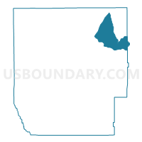
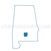
HARRISON'S, Butler County, Alabama
About
Outline

Summary
| Unique Area Identifier | 521288 |
| Name | HARRISON'S |
| County | Butler County |
| State | Alabama |
| Area (square miles) | 31.76 |
| Land Area (square miles) | 31.51 |
| Water Area (square miles) | 0.24 |
| % of Land Area | 99.23 |
| % of Water Area | 0.77 |
| Latitude of the Internal Point | 31.86383600 |
| Longtitude of the Internal Point | -86.50255000 |
Maps

Graphs
Select a template below for downloading or customizing gragh for HARRISON'S, Butler County, Alabama


Neighbors
Neighoring Voting District (by Name) Neighboring Voting District on the Map
- CENTRAL VOLUNTEER FIRE DEPT., Butler County, AL
- Chapel Hill Community Center, Crenshaw County, AL
- DUNBAR COMMUNITY CENTER, Butler County, AL
- Honoraville Volunteer Fire Station, Crenshaw County, AL
- MIDWAY, Butler County, AL
- SEARCY VOLUNTEER FIRE DEPT., Butler County, AL
- STEINER'S STORE, Butler County, AL
Top 10 Neighboring County Subdivision (by Population) Neighboring County Subdivision on the Map
Top 10 Neighboring Unified School District (by Population) Neighboring Unified School District on the Map
Top 10 Neighboring State Legislative District Lower Chamber (by Population) Neighboring State Legislative District Lower Chamber on the Map
Top 10 Neighboring State Legislative District Upper Chamber (by Population) Neighboring State Legislative District Upper Chamber on the Map
Top 10 Neighboring 111th Congressional District (by Population) Neighboring 111th Congressional District on the Map
Top 10 Neighboring Census Tract (by Population) Neighboring Census Tract on the Map
- Census Tract 9532, Butler County, AL (4,327)
- Census Tract 9636, Crenshaw County, AL (3,180)
- Census Tract 9527, Butler County, AL (2,439)